5. Thermal maps 5.2 Thermal map of the morning (map-III)
 Download of map-III
 (as a PDF file)
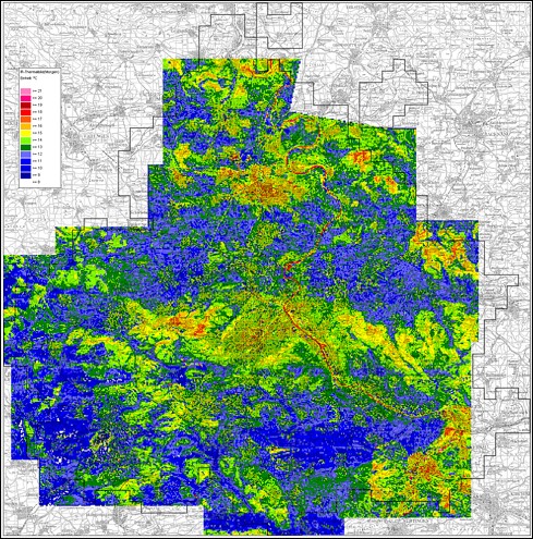
The morning flight took two hours and ended 49 minutes before sunrise.
Minimum air temperatures are reached at this time of the day and as a result of the lack of air exchange during the analyzed radiation night, particularly strong cooling effects can be observed near the ground. For a better illustration of the changes between evening and morning flight, a consistent colour temperature scale is used for both measuring flights. We still have to consider, as mentioned in the context of the evening flight, an interface with the later integrated measuring flight of the year 1987 in the northern and southeastern part of the area under investigation.
The deep blue areas at the bottom of the temperature scale (50 °F/10 °C) have grown to the extent that temperatures below the measurement range (surface temperatures below 50 °F/10 °C) are not limited to strongly cooled technical surfaces, like hall roofs of industrial and commercial plants. The coldest temperatures are measured above elevated open land as well as in vegetation areas characterized by confluent cold air in valleys and basins of the area under investigation rising towards the South and Southwest. Particular cooling areas can be found for example in the Büsnau valley (north of Stuttgart-Vaihingen), in the Glemstal valley near Leonberg, around the open land between Renningen and Dagersheim, in the Würmtal valley near Ehningen, in the Aichtal valley near Waldenbuch as well as in the course of the Körschtal valley with the Filder plains adjacent in the South.
Important temperature drops during the night are not restricted to unbuilt areas. Places in the southern part of the area under investigation have also cooled down significantly, showing that the excessive temperature above settlements was used up and temperatures have levelled at the bottom of the temperature scale. It is the same for forested areas, whose cushion of warm air in the canopy has only been preserved in dense forests on the top of hills. Among these areas are the forest between Heukopf and Schwarzwildpark as well as the Spitalwald forest in Stuttgart, the Buocher plains and the Schurwald forest.
The extent to which country roads, motorways, estates and forests cool down during the night allows for a delimitation of cold air catchment areas, and the cold air advancing from valleys into forested areas enables an estimation of the altitude of the concentration area via the topography of the forest soil. Examples of such an image interpretation are the Feuerbach valley, the Glemstal valley, the Siebenmühlental valley and the Hölzertal valley east of Magstadt. Heavily cooling elevated grasslands, like west of Maichingen, cannot be integrated into the thermal scheme of the cold air catchment areas with a comparable cap as these are indigenous cold-air pools and no concentration areas.
A consideration of the cold-air potential in the South of Stuttgart contributes to the explanation of the strong cooling of large parts of Stuttgart's city and Feuerbach during the night. The Feuerbach and Nesenbach valley leading to the inner city are connected to the region around Glemstal, Gallenklinge and Heidenklinge or Siebenmühlental, Filder region, Ramsbachtal and Weidachtal - large areas producing cold air. The cooling during the night indicates the existence of a local wind system and night mountain winds also in cities like Esslingen and Sindelfingen.
The city of Ludwigsburg, which appears relatively warm in the morning picture, is less influenced by the aeration of thermally induced winds due to its topographic structure. When discussing the temperature difference between Ludwigsburg and Stuttgart, which seems significant at first glance, we have to consider that the sharp contrast between the colours yellow and green in the thermal picture signifies nothing but the small difference of 1 K and that around the borderline of both temperature steps even a small temperature variation can lead to a change in colours.
And what is more, the relatively strong heat island effect in Ludwigsburg is the result of the absence of a night mountain wind and of the generous pattern of roads and compacted surfaces.
What is striking in Kornwestheim is the more intense cooling of the large marshalling yard in comparison with the roads. The reason for this is the rapid cooling of the railway tracks due to the high pore volume of the ballast bed under the tracks. The high pore volume thermally isolates the track as a whole from the ground as well as each ballast pebble from the others and this is why the sun warms only a thin layer of ballast (to very high temperatures) during the day. When the ballast releases the heat during the night, no further heat comes from below and in consequence, the ballast bed cools down rapidly.
In this context, railyards differ from other compacted surfaces like Stuttgart's airport, where further heat comes from the massive substructure until morning. Huge parking spaces with a high degree of sealing have similar effects.
But the heat retaining capacity of waters cannot be surpassed by any other technical objects or landscape elements. The lakes have kept their high summer levels of about 66.2 to 69.8 °F (19-21 °C), which is about the same for all. Sample measurements of the water temperature up to 3 cm from the surface gave an average cooling of the lakes of about 2 K between the evening and the morning flight.
The running waters of the Neckar, on the contrary, show bigger temporal and local temperature fluctuations due to water inlets and the mixing of water near sluices and weirs.
| |

|
 |
|
| © City of Stuttgart, Office for Environmental Protection, Section of Urban Climatology |