Climatic conditions in Stuttgart
A city's climate is determined by its latitude, altitude, type of subsoil it is built on, the orography as well as man-made changes in the landscape. Stuttgart's climate is marked by its position in the wide Neckar basin, shielded by the Black Forest in the West, the Swabian Alb in the South, the Schurwald in the East and the Stromberg and Heuchelberg region in the Northwest. The city's position has a significant influence on all climatic elements like radiation, temperature, humidity, precipitation and wind.
Due to geological conditions, Stuttgart provides a variety of landscapes - arable land in the North and the rolling Keuperberg region in the South which passes over into the Filder plain further in the South. Another characteristic is the Neckar Valley which divides the landscape from South to North (STUTTGART HANDBUCH, 1985).
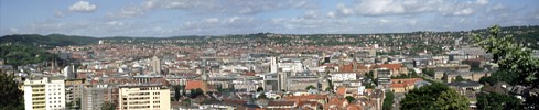
Stuttgart's centre is not situated by the Neckar but lies in a Keuper sink (about 240 m above sea level), which is almost completely surrounded by mountain ranges reaching up to 500 m asl. The only opening to the Neckar Valley is in the Northeast along the Nesenbach stream. In the southwest direction, the Nesenbach proceeds in a narrow valley, which has a similar importance for Stuttgart's air supply as the Höllental valley with its Höllentäler mountain wind system has for the city of Freiburg (the photo shows a relief picture of Stuttgart, viewed from the North).
Solar radiation in StuttgartAs Stuttgart lies on the lee side of the Black Forest and the Swabian Alb, the average hours of sunshine it sees per year are relatively considerable (1,720 hours). While the sun shines only less than 60 hours in December, it shines more than 230 hours in July. The maximum amount of global radiation per month is reached in August (50 kJ/cm2), in December it is only 9 kJ/cm2. The annual amount of global radiation is about 400 kJ/cm2. A share of 39 % of the astronomically possible sunshine is achieved in Stuttgart, a fact which is mostly due to cloudiness. The summer months lie above the annual average (up to 49 % of the possible sunshine hours), the winter months below (less than 25 %). As a result of orographic conditions, solar radiation may vary significantly from one place to another. This is especially true for slopes with a different inclination and direction to the sun (average annual radiation). In consideration of an energy saving urban land use planning, this aspect is to play an important role in future projects (BAUMÃLLER et al., 1993) (
Solar Atlas Stuttgart).
Temperature in StuttgartStuttgartâs climate is mild with an average annual temperature of about 50 °F (10 °C) in the basin of the city and about 47 °F (8.4 °C) in the more elevated outskirts situated about 400 m asl. Besides the Upper Rhine Valley, Greater Stuttgart is one of the warmest regions in Germany. The month of July is the hottest month with an average temperature of 65.9 °F (18.8 °C), while temperature in January averages only 34.3 °F (1.3 °C). Stuttgart's centre has about 150 days above freezing. Thanks to the generally mild climate, wine growing has been important here for a long time. Until the administrative reform in 1972, Stuttgart had been Baden-Württemberg's biggest wine growing region. Long-term measurements show that the Filder region has an annual average of 91 to 94 frost days, whereas Stuttgart's centre has only 70. This phenomenon is called the heat island effect. There are 28 to 32 summer days in the Filder region, as compared with 40 to 47 summer days in the Neckar Valley and the Stuttgart bight. A combination of high temperature and humidity turns Stuttgart into a region with higher heat stress (about 30 days) and only occasional cold stress (JENDRITZKY, 1993) (
Climate Calendar Stuttgart).
Precipitation in StuttgartA region's climate largely depends on precipitation. It has an influence on vegetation, on the sewerage system and rain detention reservoirs as well as on the cleaning of the atmosphere through wet deposition. The region of Stuttgart has very little precipitation compared to other regions in Germany. This is mostly due to Stuttgart's above-mentioned position on the lee side of the Black Forest and the Swabian Alb. The average annual amount of precipitation in the centre is 679 mm. The biggest amount of precipitation falls, like in the rest of Southern Germany, in summer, mostly in the months of June and August. The little amount of precipitation and the rapidly growing population in the Stuttgart region led to the necessity of fresh water supply from other regions. Fresh water is mostly provided from the Swabian Alb (by the Landeswasserversorgung Association) as well as from Lake Constance (by the Bodenseewasserversorgung Association) (
Climate Calendar Stuttgart).
Wind conditions in StuttgartWind is characterized by its speed and its direction. It regulates the spreading of air pollutants and therefore plays a decisive role for air hygiene. A major element of Stuttgart's climate is the light wind, a fact which is not only the result of the city's position between two bights of the Keuper plains. The whole Neckar Valley is known for low wind speeds and very frequent lulls. This is the result of small air pressure differences common to Southern Germany and of Stuttgart's sheltered position between the Black Forest, the Swabian Alb, the Schurwald and the Swabian-Franconian Forest. Due to orographic conditions, it is impossible to indicate a consistent wind rose for the whole of Stuttgart.
(See current wind field) What is the most likely wind rose to describe the local wind is the wind rose at Stuttgart airport. For the rest, there is another wind in every place. The sheltered position between the surrounding mountain ranges leads to a frequent development of local wind systems, especially at the slopes and in the valleys. Even if these winds have no high wind speeds, they play a significant role for the local air supply in some city districts (
Climate Calendar Stuttgart).
 300 years of urban climate in Stuttgart - a retrospection -
| |

|
 |
|
| © City of Stuttgart, Office for Environmental Protection, Section of Urban Climatology |