4. Thermal situation 4.1 Thermal pictures
Infrared thermography provides a picture of the current temperature distribution on the earth's surface. This method is based on the fact that the surface temperature of an object can be determined in a non-contact measurement from the distance by measuring its infrared thermal radiation. Aircrafts scan entire regions in order to detect thermal infrared and provide high-resolution thermal images.
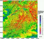
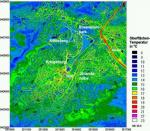
The resolution in our case is 7.5 m by 7.5 m at a flight level of 3,000 m above ground. The measuring arrangement captures temperature differences of the earth's surface of the order of 0.05 K. The thermal maps from 18 and 19 August 1988 were analysed in steps of 1 K for practical reasons and they cover the range from 46.4 ┬░F (8 ┬░C) to 73.4 ┬░F (23 ┬░C). Figures 4-1 and 4-2 include the corresponding 15-level colour temperature scale. It is the same for both measuring days and also applies to figures 4-3 and 4-4.
Differences in temperature structures in the city as a result of development can be displayed this way, also in respect of the progress of night cooling. The purpose of the analysis is to know more about air exchange processes and to determine those areas within the city which play an important role in the formation of local wind systems. Temperature in the city is higher than in the open landscape because of what is called the urban heat island effect. The reasons for this temperature excess in built-up areas especially during the night are numerous, some of the most important are: the applied surface materials, the sealing of the soil surface, the lack of vegetation, the prevalence of vertical surfaces, the generation of artificial heat, altered radiation currents and wind conditions. This effect is even intensified in Stuttgart due to the city's position in the basin. On the other hand, cold air flows from the surrounding elevated outskirts can reach the built-up city centre in the night over slopes and clefts and can so contribute to thermal exchange. An analysis of the infrared thermography demonstrated this effect vividly.
 Evening situation (figure 4-1)
 |  |
 |

Fig. 4-1: Surface temperatures in Stuttgart after sunset (18 August 1988)
 |  |
On a summer day like this, with little wind and much radiation, the cooling of the earth's surface is already in full swing one hour after sunset and the progress of cooling differs according to the composition of the ground, vegetation and development.
What simplifies the orientation in the thermal picture is the road network, which contrasts sharply with its surroundings due to the higher surface temperatures at this time of the day. Asphalt surfaces, walls and waters have stored the heat during the day and release it slowly. The red and yellow areas mark surface temperatures between 64.4 ┬░F (18 ┬░C) and 71.6 ┬░F (22 ┬░C). The less populated surrounding region is considerably cooler. Some areas do not even have temperatures as high as 50.0 ┬░F (10 ┬░C). The aerial picture displays among other things the openings where fresh air enters the city. A classic example is the Feuerbach valley in the northwestern part of the picture. The city districts Kaltental and Heslach are also cooler than the rest, which is evidence of the cold air that flows through the Nesenbach valley and into the city centre. The city centre presents itself as a veritable heat reservoir. Areas in the city centre which are the first to release heat, however, are parks and roof surfaces (most evidently that of the central station) while the road network, which is bordered by built-up areas, stores heat. The cushion of warm air in the canopy of dense deciduous forests on knolls has a similar effect in the thermal picture but is completely different in climatic terms.
 Morning situation (figure 4-2)
 |  |
 |

Fig. 4-2: Surface temperatures in Stuttgart before sunrise (19 August 1988)
 |  |
Before sunrise, the city is in the final stage of night cooling, which is only influenced by the thermal behaviour of the urban landscape itself. Only inner city streets are warmer than 60.8 ┬░F (16 ┬░C). The waters, which are dull in what is temperature changes, did not cool during the night and are the warmest elements in the thermal picture now. The wooded elevated outskirts stand out from the valleys and sinks affected by cold air near the ground level. A comparison between the heavily cooled city districts in the Nesenbach valley and the central part of the west basin demonstrates the effects of the cold air dominating the Nesenbach valley. Areas that cooled most are vast roof surfaces of ample halls (see central station and parcel post office) and the large railway constructions ahead of the main station including the curve track of the holding sidings.
 Thermal situation of the inner city (figures 4-3 and 4-4)
 |  |
 |

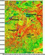
Fig. 4-3: Surface temperatures in the inner city after sunset (18 August 1988)
 |  |
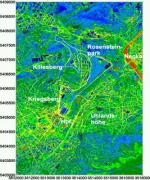
Figure 1-1 illustrates that Kriegsberg and Uhlandsh├Âhe narrow the city basin significantly near the central station and that the valley opens more flatly and broadly in the Northeast to the Neckar valley. The thermal picture from the evening flight (fig. 4-3) depicts the built-up areas there as warm as the central part of the city basin. Towards morning, however, cooling has further proceeded in the northeastern part due to larger green and open spaces, which separate three built-up areas from each other in the morning thermal picture (fig. 4-4), i.e. the area along Heilbronner Stra├če between T├╝rlenstra├če and Friedhofstra├če, the building area between the North Station and Rosensteinstra├če as well as the area between Neckartor, lower castle gardens and Villa Berg.
Two cool areas with openings for fresh air stand out in the morning thermal picture: the clefts Eckartshalde (the former city nursery) and Wartberg-Klinge/Steinberg-Klinge in the northern part of Stuttgart. These clefts are particularly important because they link the large green spaces of the Feuerbach heath and the Killesberg plain with the lower areas along Heilbronner Stra├če and the Pragfriedhof cemetery and Rosensteinpark. Evidence of these clefts' cold air efficiency, especially of M├Ânchhalde that begins at Kriegsberg near the central station, is given in the thermal picture where the road network is locally almost invisible or heavily blurred. The lack of climate-relevant slopes in the northern part of Stuttgart is counterbalanced by the vegetation in the castle gardens, in Rosensteinpark, in the Pragfreidhof cemetery and in the Villa Berg park (which belongs to the eastern part of Stuttgart).
The railway tracks in the triangle between Rosensteinstra├če, Rosensteinpark and lower castle gardens are perceived as a cooled down area in the morning picture compared to the Pragfriedhof cemetery. The reason for the rapid cooling of the railway tracks in contrast to roads is the high pore volume of the ballast bed beneath the rails. The high pore volume thermally isolates the track as a whole from the ground as well as each ballast pebble from the others and this is why the sun warms only a thin layer of ballast during the day. When the ballast releases the heat during the night, no further heat comes from below and in consequence, the ballast bed cools down rapidly.

 |  |
 |
 | 
Fig. 4-4: Surface temperatures in the inner city before sunrise (19 August 1988)
 |
This means that a considerable temperature difference, which can initiate air movements, is maintained in immediate vicinity of the inner city and in the range of the crucial Nesenbach valley. Today's railway territory - even if it is man-made and significantly modifies the relief of the valley bottom - can easily be overflown by the wind due to its structure and is therefore an important zone for the air exchange in the inner city. This leads us to the question of the climatic properties of large railyards. The German Meteorological Service (Deutscher Wetterdienst, DWD) carried out a detailed analysis at marshalling yards in Munich (DWD, 1994) with the result that railway tracks cool down more during the night than built-up areas (as pictured above). But they remain warmer than inner city parks or the open countryside. The heat island effect is less distinctive at marshalling yards than in more densely populated districts. Compared to former agricultural land, the construction of railway tracks would only have a minor influence on the temperature balance. As for humidity, there are no measurable deviations from the agricultural surroundings in the monthly averages either. Local circulation systems emanating from the territory of the marshalling yard could not be detected, nor the obstruction of wind systems by the railway tracks. These results show that railyards rather resemble open spaces than built-up areas in terms of climatic behaviour. If you count the Vogelsang valley in the west of Stuttgart, the Hasenberg slopes and the junction of the Nesenbach in Heslach among the fresh air openings of the southeastern valley border, and if the centre of the urban heat island is situated between Silberburg and Kriegsberg, you get the idea of the air mixing conditions near ground level directed from Southwest to South and Southeast oriented towards the inner city.

| |

|
 |
|
| © City of Stuttgart, Office for Environmental Protection, Section of Urban Climatology |


